More than three thousand five hundred properties are identified as being at risk from coastal flooding or erosion along Christchurch Bay and Harbour over the next one hundred years, according to a newly adopted long term strategy.
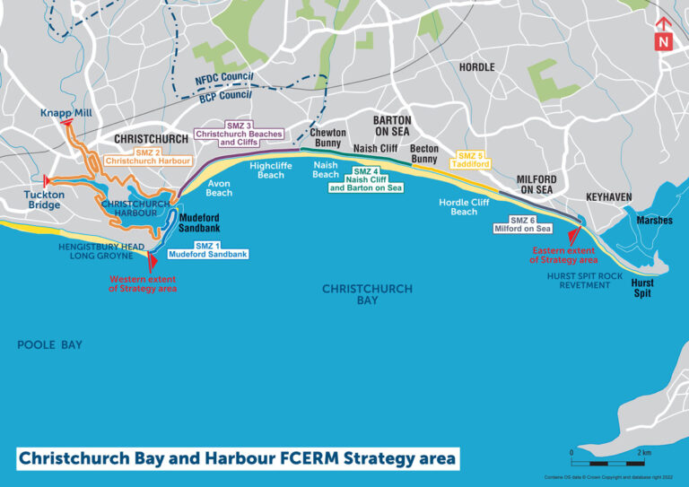
The Christchurch Bay and Harbour Flood and Coastal Erosion Risk Management Strategy has been formally agreed by Bournemouth, Christchurch and Poole Council and New Forest District Council, covering the coastline from Hengistbury Head Long Groyne to Hurst Spit, including Christchurch Harbour, and setting out how risks will be managed over the coming century.
Produced with the Environment Agency and technical consultants AECOM, the strategy highlights the impact of ageing coastal defences and climate change, including rising sea levels, and estimates that doing nothing could lead to around one billion pounds of damage in cash terms over one hundred years.
Councillor Andy Hadley from BCP Council said the plan provides a joined up approach for the whole stretch of coastline, ensuring work in one location does not create problems elsewhere, while also supporting environmental improvements and access to national funding streams.
New Forest District Council’s Councillor Geoffrey Blunden said the strategy includes flexible options for each area, ranging from nationally assessed schemes to locally informed approaches based on public views, allowing decisions to reflect funding availability at the time of delivery.
The councils say the strategy gives clarity on managing future risks, while recognising that central government funding will not cover all costs and that partnership funding will be needed over the next twenty years.